Best Yosemite Hikes Away from the Crowds


8 Must-Do Yosemite Hikes
Yosemite’s classic hikes like Half Dome, Yosemite Falls and the Mist Trail are not to be missed. After all, these trails offer up some of the most iconic national park experiences and views anywhere. But that also means you have to share these amazing spots with the crowds. If you’ve been there, done that, or want to get away from the masses without missing out on some of Yosemite National Park’s best views, we’ve got a few suggestions.
We talked to John DeGrazio from YExplore—which offers custom guided Yosemite adventures—to find out which off-the-beaten-path Yosemite hikes he recommends for every type of hiker. Here are his picks…

1) West Valley Loop Trail
Difficulty: Easy
Distance: 6.5 miles
Elevation change: Minor (flat)
Most people will hike the eastern section of the Valley Loop Trail toward Mirror Lake. But John says you can hike the western valley floor loop along the Merced River for classic views of Sentinel Rock, Cathedral Rocks, Bridalveil Fall, El Capitan and Yosemite Falls. Don’t let the mileage scare you off, this is an easy stroll that you can spend 2-3 hours doing, or the whole day if you want to bring a picnic and enjoy your own riverside nook. Getting there: Trailhead begins just west of the El Capitan Bridge near the center of Yosemite Valley. Park along El Capitan Drive.
2) Merced Grove Trail
Difficulty: Moderate
Distance: 3 miles
Elevation change: 600 feet
The obvious choice for those interested in seeing Yosemite’s giant sequoias—some of the largest and oldest trees on the planet—is the popular Mariposa Grove near the park’s south entrance which has more than 500 mature giant sequoias. To experience these giant beauties in complete solitude, however, opt for the Merced Grove Trail instead. It may be home to only 20 mature trees, but having them all to yourself is well worth the trade. Getting there: Located near the Big Oak Flat park entrance, the trailhead is just a few miles west of Crane Flat, where the Tioga Pass Road begins.
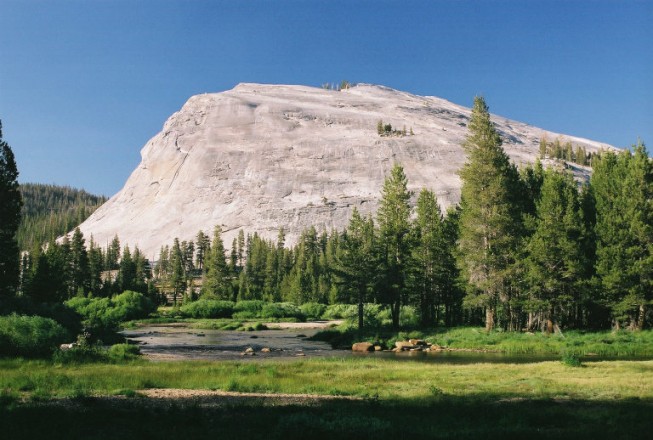
3) Lembert Dome & Dog Lake
Difficulty: Moderate
Distance: 4 mile loop with Dog Lake
Elevation gain: 750 feet
Many people notice the distinct feature of Tuolumne Meadows known as Lembert Dome as they drive by or stroll through the meadow, but fewer know of the rewarding views on top. According to John, it’s breathtaking. “You’re right above Tuolumne Meadows, looking at the Cathedral Range and two of the tallest peaks in Yosemite—Mt. Dana and Mt. Lyell,” he told us. After you make it to the top, he suggests sneaking around the back side of the mountain to have a picnic lunch at Dog Lake, which is another spot that not too many people know about. Getting there: Trailhead begins at Lembert Dome parking area on Tioga Road just past the Tuolumne Meadows visitor center.
4) Sentinel Dome/Taft Point Loop
Difficulty: Moderate
Distance: 4.9 miles
Elevation change: 1,000 feet
The Sentinel Dome/Taft Point Loop combines two underrated hikes into one spectacular experience. At one end of the trail you can climb to the top of one of Yosemite’s famous domes with little effort for stunning views of the park’s most prominent landmarks. At the other, you can dangle your feet off the edge of a cliff a mile above Yosemite Valley (or not). Getting there: Trail begins at the Sentinel Dome/Taft Point parking lot 6 miles east of the Bridalveil Creek Campground turnoff on Glacier Point Road.
5) Inspiration Point
Difficulty: Moderate
Distance: 7 miles
Elevation gain: 1,400 feet
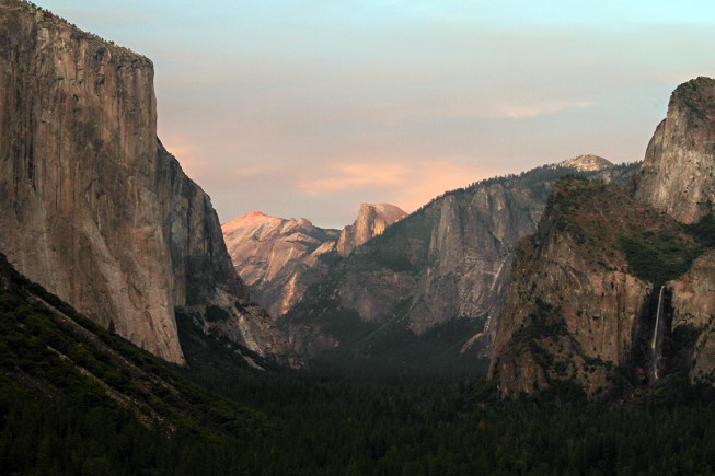
According to John, the old stage coach road that leads hikers up the south rim of the valley to Inspiration Point is not a really well-known trail at all. Yet, it’s the place where the first westerners came down into Yosemite Valley, and it’s where modern day visitors can snag the classic postcard view of El Capitan and Half Dome without having to fight the tour bus crowds at Tunnel View. Getting there: Trailhead leaves from Bridalveil Fall parking lot. If you’ve got less time, you can also make this a 2.6-mile roundtrip hike by leaving from the Tunnel View parking lot.
6) Mt. Hoffmann
Difficulty: Strenuous
Distance: 6 miles
Elevation gain: 2,000 feet
You have to work for it, but the Mount Hoffmann hike at the geographic center of Yosemite National Park doesn’t disappoint. The trail takes you past May Lake, one of the park’s most scenic lakes, before ascending the top of Mt. Hoffmann for mind-blowing panoramic views. John says that it’s not on anyone’s radar, but every time he takes people on this hike they can’t believe how spectacular it is. Getting there: From Tioga Road take the May Lake turnoff. From the turnoff it’s 1.8 miles to the trailhead.
7) Cloud’s Rest
Difficulty: Strenuous
Distance: 14.4 miles
Elevation gain: 1,775 feet
Half Dome may be the top hike on everyone’s bucket list, but to those in the know, Cloud’s Rest is the best Yosemite hike. From the top of Cloud’s Rest, not only do you get a nearly identical view as you do from the top of Half Dome, but looming giant and close you actually get one of the best views of Half Dome too. Sure, it’s a strenuous challenge, but the rewards are overwhelming. Getting there: Park at the Sunrise Lakes Trailhead at Tenaya Lake along Tioga Road for the most direct route.
8) Grand Canyon of the Tuolumne
Difficulty: Strenuous
Distance: 28.1 miles one-way
Elevation change: 7,800 feet
John calls the Grand Canyon of the Tuolumne the quintessential Yosemite experience, and it’s easy to understand why. As the trail follows the scenic Tuolumne River downstream it winds past picturesque waterfalls and cascading rapids, over shimmering granite slabs and through luscious alpine forest into the heart of Yosemite’s “Grand Canyon.” Then, right before reaching Hetch Hetchy Reservoir, you’re challenged with an invigorating ascent back out of the canyon. At nearly 30 miles, this hike is best done as a 4-day backpacking trip. Getting there: Hike begins on the Glen Aulin Trailhead at Tuolumne Meadows. Follow Tioga Road to the Lembert Dome parking area. You will need two cars, one at the Glen Aulin Trailhead and one at White Wolf campground (also off of Tioga Road).

Sign up for Our Newsletter